Lead researchers Gilly Burton and Caroline Wallis
Download the Charles Street history as a .pdf (1.6Mb)
Introduction
With his coming of age in 1783 the Prince of Wales embraced Brighton as his seaside residence. Dr Russell’s endorsement of the healing powers of the sea had already brought the town to public attention and it began to develop rapidly with visitor numbers becoming significant.
During the mid to late eighteenth century the demand for places to stay during the ‘season’, which ran between July and March, increased dramatically. Lack of accommodation became a significant problem, with visitors having to stay in nearby Lewes due to Brighton being fully booked.(1) The accommodation crisis sparked a building boom in the area east of the Steine and Charles Street was one of the first to be constructed. The farmland in this area was ideal for development as its location, close to the Steine, was perfect for the fashionable visitors of Brighton since it was within walking distance of the healing waters of the sea and the newly established ladies’ bathing machines.
Charles Street is located in what was historically called Little Laine in Cliff Furlong between the seafront road to Rottingdean (Marine Parade) and the leakway dividing it from the Upper Furlong (St James’s Street). Thomas Kemp owned the former farmland according to the Terrier, but in 1785 builder Stephen Wood purchased the freehold of two pauls, and two further pauls were leased to him.(2) Later, according to Sue Farrant, the author of Georgian Brighton 1740 – 1820, Wood was able to enfranchise the two copyheld pauls of land. It measured approximately “108 feet wide from east to west and 200 feet long from the cliff top leakway to the furlong’s northern boundary."(3) This area provided Wood with the opportunity to cash in on Brighton’s growing popularity and to build one of the first new areas of the town.
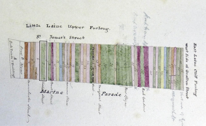
The street, like its neighbours Broad Street and Manchester Street, was built “along the cliff top…at right angles…following the orientation of the paulpieces and expanding the full width of the furlong."(4) The land was protected by covenants which dictated the type of property which could be built on the land, and this meant that most of the houses built consisted of three storeys “a basement and garret [an attic] and a small yard with a privy at the rear.(5)
In Edward Cobby’s 1799 Brightenhelmstone Directory, Wood is noted as a Surveyor of the Highway as well as a builder and is recorded as living at 13 Charles Street.(6) As well as Charles Street, Wood ran two lodging houses in the North and South Parade. Both of these establishments were of quite high standard, with 11 South Parade consisting of one drawing room, one parlour room, five best beds and six servant beds.(7) Wood, like many builders of the time, could not afford to develop the whole of the area he had purchased and leased, so he built a few houses – including number 13 – to show the street’s economic potential. He then sold the remainder of the land to others who would complete the rest of the street.
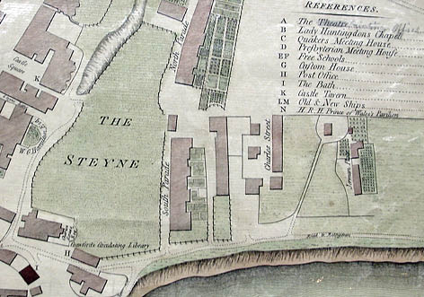
2) Map of Brightelmstone, 1788. Image courtesy of the Royal Pavilion & Museums, Brighton & Hove
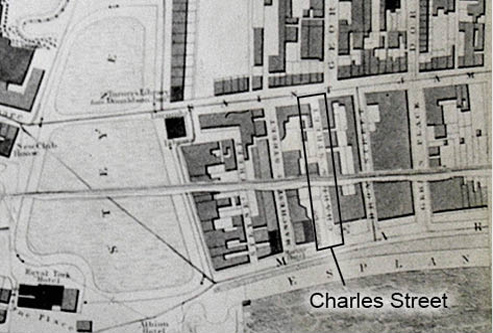
3) J. Pigot-Smith map of Brighton, 1826. Image courtesy of the Royal Pavilion & Museums, Brighton & Hove
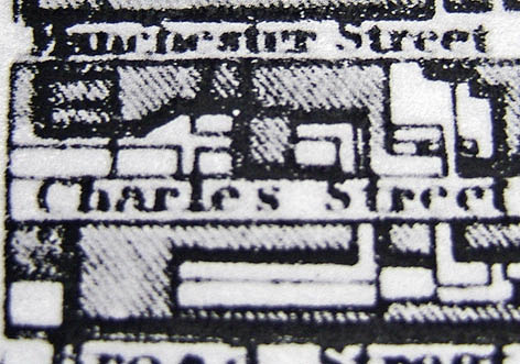
4) Map of Brighton, 1830. Image courtesy of the Royal Pavilion & Museums, Brighton & Hove
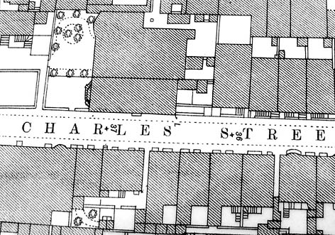
5) OS map of Brighton, 1875. Image courtesy of the Royal Pavilion & Museums, Brighton & Hove
Development began on the east side of the street but it has been hard to decipher which houses were built first. However what is clear is that by 1799 the street had one boarding house at number 12 run by a Mary Kirby. This was one of only seven listed in Brighton. There were also seven lodgings and three lodging houses. In 1788 Charles Street made its first appearance on a map of Brighton and by 1822 it is recorded that the street consisted of sixteen houses.(8)The street continued to be developed until eventually there were twenty-three houses. Today the street consists of twenty-six houses.
An 1826 map of the area shows that running between Broad Street and Charles Street were two twittens (this term is a Sussex name for a passageway.) A document dating from 1819 confirms the presence of at least one twitten. It states that number 7 Broad Street enjoyed a right of way – through a passage onto Charles Street – and shared a well with the four adjoining houses.(9) Today the twittens are disguised, one between numbers 5 and 6 Charles Street concealed behind a black door and the other by a small wooden slated door between numbers 8 and 9 Charles Street.
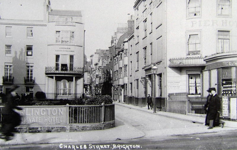
The houses in Charles Street were built with bow-fronted windows or three sided bay-fronted windows to “give more light and a greater feeling of spaciousness inside,"(10) and to afford a view of the sea. The houses were not all built at the same time and today, they are not uniform in appearance; some are rendered, whilst others - for example number 11 - are part-finished with mathematical tiles. Pevsner suggests that numbers 9-12 and 20-23 originally used tiles(11) although not all of the properties seem to display these today. Mathematical tiles are black glazed tiles which are laid on the exterior of timber framed buildings to create a look similar to brick without having to pay the brick tax of 1784 - 1850.(12)
The street brings to mind the scene noted in William Thackeray’s Vanity Fair:
“Sometimes it is towards the ocean — smiling with countless dimples, speckled with white sails, with a hundred bathing-machines kissing the skirt of his blue garment — that the Londoner looks enraptured: sometimes, on the contrary, a lover of human nature rather than of prospects of any kind, it is towards the bow windows that he turns, and that swarm of human life which they exhibit.
From one issue the notes of a piano, which a young lady in ringlets practices six hours daily, to the delight of the fellow-lodgers: at another, lovely Polly, the nurse-maid, may be seen dandling Master Omnium in her arms: whilst Jacob, his papa, is beheld eating prawns, and devouring The Times for breakfast, at the window below.”
Architecture and materials
The properties in Charles Street are amongst the first purpose built visitor homes in Brighton. Like the local houses constructed before them and after, they are made in part of bungaroosh (a local Sussex name for flint and lime wall), brick, lime-plaster and timber. In Charles Street, however, the relatively rare mathematical tile’ was also used on some of the facades.
A number of the houses in the street have been redeveloped, to some extent, in the recent past and several are virtually newly built. There are also examples of 19th century interventions, such as at No. 19, discussed in detail below, and early-20th century works, which are to be found at the SE corner of the street, technically Marine Parade.
Despite the pressures of time, by far the majority of the houses have retained (or regained) double hung sash windows with Georgian pattern glazing.
The street has a very distinct personality, one shared to some extent by the other early-streets in the neighbourhood, with the thoroughfare and the houses therein easily identified as different from late-Regency development by the scale of works. Contrast for example, Charles Street with Waterloo Street, Hove, both built for visitors, but some 30 years apart.
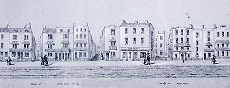
6) Drawing by William Alfred Delamotte. Image courtesy of The Regency Society.
The developers of Charles Street were enthusiastic that their dwellings would offer high quality abodes competing successfully with others available nearby; both in Brighton and slightly further afield. Nevertheless, as the street and homes become dwarfed by the developments of the 1820s, it is interesting to speculate as to how long the properties stayed highly desirable visitor locations.
Today, the street is included within the East Cliff Conservation Area, further information about the architecture and materials used can be found within the Conservation Area publications.
Amenities
In 1773 a board of commissioners was set up in Brighton to organise the “paving, lighting and cleansing of the streets [and the maintenance of] the streets, pavements, footways and lamps in public places.”(13) They were also responsible for the prevention of cliff erosion.
Like many streets being built in the last twenty years of the eighteenth century in the area east of the Steine, there was no paving in Charles Street. It is unclear when the street finally got proper road surfacing, but Sue Berry, author of Georgian Brighton, notes that the Town’s Commissioners did not provide paving until all the houses were built in the Little Laine area.
The Commissioners were the caretakers of the town. Their role was to ensure the improvement and maintenance of the streets of Brighton, cleaning and removing ‘nuisances’. One such noted nuisance was in 1810 in Charles Street, where it is recorded that a number of dung-heaps were causing “a nuisance.”(14)
The street received street lighting in July 1802 along with its neighbours. The lamps were serviced and lit by Richard Knighton who won the lighting contract from the Town’s Commissioners in 1801. (15) It has yet to be established when Charles Street first received electricity and mains water; these are things which need further investigation. However, it is known that by 1899 the street had telephones installed. Although not every house would have had one, the Wilsons of number 1 are the first family and business in the street to have a telephone number recorded in the Brighton Street Directory.
Notable buildings
Charles Street as a whole is notable because, as has been mentioned in the introduction, it was one of the very first streets to be built in the East of Steine area. However, there are a set of houses in the street which are particularly important to mention because they are listed. These are houses 9-12 on the east side and 20-23 on the west side, which were listed in 1971 after a long-running battle to save the buildings on the west side, which is described in the section below, entitled Proposed Development.
Notable people
No. 22, one of the houses on the west side appears to have quite a link with the world of entertainment. In the 1950s Jack Tripp, the famous pantomime dame, lived there and during his stay in the street had many glamorous guests to stay, including Diana Dors.
In the latter stages of the twentieth century, another house was home to John Henty, once of BBC Radio Brighton. John, has also been the chairman of the Max Miller appreciation society, and has recently written a children’s book called Cheshire – the Cheese Loving Bear to raise money for the Royal Marsden Hospital Charity.
Residents and trade
Charles Street was created for Brighton’s visitors; lodgings, lodging houses and boarding houses filled the street, and by 1879 it even had a hotel. With the area east of the Steine being in such close proximity to the sea and to the town’s fashionable heart, accommodation in Charles Street was at the higher end of the market. Although lodgings, lodging houses and boarding houses could all be listed as offering resort accommodation, the three differed significantly in type.
Lodgings provided the cheapest option. These offered guests a room within a person’s house. Interestingly, people did not have to own their property to offer this form of accommodation, and there were many cases of sub-letting during this time.(16) Although there are records of lodgings providing servant accommodation, the houses would not have been big enough for a full staff. The first confirmed recording of lodgings in Charles Street is, as mentioned earlier, in Cobby’s 1799 Directory. Cobby notes that numbers 2, 3, 4, 5, 6, 8 and 9 all provide lodgings, they all have one parlour room, two best bedrooms and one servant room and they are all run by men, apart from number 6 which is run by Mary Wille.(17)
Lodging houses provided a better standard of accommodation and allowed a family to bring their own full staff of servants with them, who would, amongst other duties, prepare the families meals.(18) Charles Street in 1799 had three lodging houses. Lodging houses required a greater financial outlay so it is hardly surprising that they were outnumbered by lodgings. The three lodging houses were at number 1, run by a Mr Henry Wafner, and numbers 10 and 11 run by a Mr George Slade. All three had one drawing room, one parlour, three best rooms and two servant rooms.(19)
The boarding house was the most expensive of accommodation options during the eighteenth and nineteenth centuries and was the precursor to the hotel. Charles Street’s only boarding house was at number 12 and was run by Mary Kirby.(20) Boarding houses provided guests with both a high standard of accommodation and meals, so visitors did not need to bring any servants with them.
Visitor accommodation has been a part of the street’s history since its conception, with the street still home to many lodging houses, bed and breakfasts and guesthouses into the second half of the twentieth century. Even today, in 2011, the street still has a foothold in its heritage with The Dolphin Guesthouse at number 10.
As well as offering holiday accommodation, Charles Street hosted a rich variety of trades. In the 1822 trade directory the following people and trades are listed; at number 1, lived Mr R Sheppard a draper and tailor; number 2, Mr J Potter the fishmonger; number 3, a strange combination of a builder and a greengrocer run by Mr E Tomsett and at number 4 was Mrs Tattam the dressmaker. On the corner of Charles Street and St James’s Street there was a butchers, which had numerous proprietors over the years, while at number 9, lived Mr Henry Solomon the Inspector of the Post Horse Duty. The mixture of trades in the street over the years has been diverse and has included confectioners, a school for girls and even a medical rubbers manufacturer.
The Wilson family
The Wilson family had a presence on Charles Street for over 120 years both as residents and as traders. The first evidence of the Wilson family in the street is in 1838 where Mr William Wilson resided at number two, and is recorded in the street directory of that year as being a plumber. It is unclear how long he lived at this address, but by 1841 the thirty year old William had moved to number 1 Charles Street. By 1851 William had married Mary and they had a three-year-old daughter, also named Mary and a ten-month-old son called Francis Thomas. From the 1851 Census data it can also be gathered that William Wilsons’ business was going strong, as he is now noted as being a plumber, painter, glazier and paperhanger who employed six men, one apprentice and one errand boy. Another indication of the family’s growing affluence is in the 1861 Census where a Harriet Burt is recorded as being employed as a servant for the Wilson’s. By 1861 the Wilsons had also had another two children, both boys, William and Alfred.
By the 1871 Census, the head of the family, William, had passed away leaving behind his widow Mary to run the business - which now employed twelve men and one boy. Both of William and Mary’s eldest sons also worked for the family, Francis as a builder and William as a clerk plumber and by 1881 Francis (under his middle name of Thomas) was running the business. Mary Wilson is no longer listed so it is presumed that she had passed away.
From the 1881 Census, it is apparent that Francis was married to Harriet (not the servant) and they had two children, Francis aged two and a baby, Mary. His younger brother William was also living with the family and works for the family business as a dealer shopman. The Wilsons also employed two domestic servants.
By 1891 the Wilsons have moved out of number one Charles Street to number 14 Devonshire Place. However looking at the trade directories, the family kept their shop and workshops at number 1 Charles Street and number 115 St James’s Street (opposite the butchers) into which the business had expanded whilst William senior was still alive.
It has been hard to ascertain where the Wilsons worked in Brighton, but with their sustained presence in the town and with the growth of their premises, Wilsons was clearly a successful Brighton family business, which was a part of Charles Street until the nineteen-sixties.
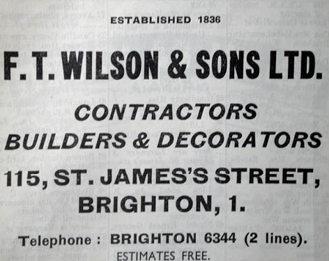
8) Advert from 20th century Brighton Directory. Image courtesy of the Royal Pavilion, Libraries and Museums, Brighton and Hove
The Rose family
In 1828 Thomas Rose and his wife Sarah, along with their three children, moved from number 29 Dorset Gardens to number 19 Charles Street.
Thomas Rose was a dyer and scourer by trade and ran his business from his Charles Street address. As a dyer Thomas would have dyed and scoured domestic items such as clothing and furnishing fabrics. Scouring involved the cleaning of fabrics and objects which could not have been cleaned at the laundry: items such as “woollen dresses…bonnets and feathers [as well as] fancy shawls, scarlet cloth, lace frills and gentlemen’s clothes."(21)
In 1840, the trade directory of that year tells us that the Rose family and their business had moved next door to number twenty. The Roses now had six children – three girls and three boys aged eight to fifteen. In 1843 the family business was growing and Thomas had added ‘calendaring’ to his repertoire of services. Calendaring was a process that was used to flatten cleaned or washed wool and it required equipment in the form of rollers, similar to a mangle.
The 1851 Census records Thomas as the ‘Master Dyer’ and employing one man, along with his family, who all had roles centering round the trade. Two of his children are absent from the 1851 Census. This could be because they no longer lived at the address, or that they may just have been away on the night of the Census. In 1861, Thomas and Sarah, both over sixty, were still very much a part of the business, although their eldest son Thomas and youngest son William were moving up in the trade and taking on more responsibility. Thomas is listed as being a shopman, whilst William – who by this time would have past his apprenticeship – was now a dyers journeyman.
By 1866 both Thomas and Sarah had passed away, leaving their sons Thomas and William to continue the family trade. However, looking through street directories and Census reports, it appears that the business did not survive for many more years, as by 1873 there is no trace of the Roses or their business in Charles Street. There could be a number of explanations for this, for example the trade could have died out, or they could have moved the business (but we have failed to locate it in another area of the town).
Peculiarly though, in the 1885 street directory, Thomas is recorded as living at number 20a Charles Street for a year, and in the 1901 Census, William is recorded as living at number 20. He is listed as ‘living on his own means’.
Number 2
Number 2 was a complete contrast to its neighbour number 1 which had a transient nature due to the inconsistencies of the beer trade.
The earliest traceable resident of number 2 was John Allen, who is listed as a Beer Retailer in the 1833 Brighton directory. However, by 1841 the registered name at the address is that of Mrs Jane Allen – presumably John had left her or died by this time. Jane lived at number 2 with her sister Sarah (who is listed as an invalid), her brother George Rice, another sister Elizabeth, her husband George plus three nephews under fifteen by the name of Holden. In the Census of 1851 Jane is forty-six years old and is still a Beer Retailer and the family was still with her, with an addition of an adopted boy called Benjamin Flint.
In the 1856 trade directory number 2 is a public house called ‘The Ship in Distress’. Jane, George, Elizabeth and Sarah lived there and ran the pub until 1862 when there was a complete change of occupancy and this began a forty-eight year history of numerous residents, name changes and uses.
When J. Mayfield took over in 1869 he changed the pub’s name to ‘The Schooner’ and over the next twenty-two years the pub had seven different owners. In 1891 ‘The Schooner’ had gone and number 2 had returned to being residential. Later it became a lodging house and remained so until 1939.
During the second half of the twentieth century or the early years of the twenty first numbers 1 and 2 were brought together and absorbed into 115 St James’s Street, which in 2008 became a Starbucks.
Number 5
Number 2 was not the only watering hole in the street; 1854 recorded a Mrs Montague at number 5 as a beer seller however in the 1861 Census it can be seen that Mrs Montague no longer resided at number 5 and the Viners had moved in. Mr Henry Viner, recorded as a publican, lived with his wife Emma, and his daughters Fanny aged eighteen, Emma aged sixteen and Sarah fifteen. In 1862 the trade directory of that year records number 5 as the ‘Eagle Inn’, and in the 1881 Census it can be seen that the pub was extended into number 6. Mr Viner ran the pub until 1886, when a Mr Henderson is noted as the new publican. 1888 saw another change, with Mr A Guiliani taking on the role of landlord and in 1891 a Mr John Christie and his family are also recorded as living and working at number 5 with Mr Guiliani. In 1893 the pub was registered as a hotel run by Mrs Scanlon. The history of number 5 and 6 involved many owners and changes of use between that of a pub or a hotel. In one guise or another, the Eagle Inn was a part of Charles Street for over seventy years but by 1927 the pub had closed, along with the ‘Ship in Distress’/‘Schooner Tavern’ at number 2.
Social Life
For an up-and-coming area in the eighteenth and nineteenth centuries, it was important to visitors that they were in close proximity to a library. A circulating library was a meeting place where visitors could announce their arrival in the town. Charles Street was no different and situated on Marine Parade, between Manchester and Charles Street, a Mr Tuppen ran a library which provided the visitors to the surrounding streets with a portal to the social elite of Brighton.
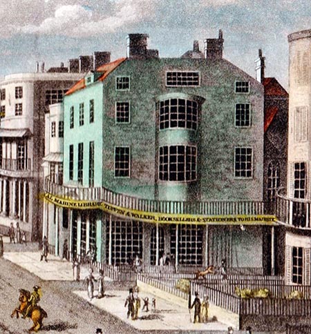
9) Advert Detail from the engraving of 'Marine Parade' after S J E Jones, c.1827, showing Tuppen & Walker's Marine Library. Image courtesy of Steve Myall.
In Wallis’s Royal edition, an 1836 guide to ‘Fashionable Brighton’ the following description of the library is supplied:
On the Marine Parade, [the library] is well supplied with every popular work, especially such as are calculated for the fair sex; and the tables (which are placed in the bow windows and command delightful views of the ocean and Chain Pier) are supplied with all the best newspapers and periodical works, as well as with several capital telescopes.(22)
The library was the social epicentre for visitors to Charles Street. However for the long-term residents of the street, one of the two public houses would have provided not only an escape from work and the trivialities of life, but with a place to interact with other local residents.
Crime
A great deal of research has already been undertaken and so far no serious crimes in Charles Street have been uncovered, however there is was a case that came to court regarding a misdemeanor.
On the 16th December 1881 the genteel Charles Street was disturbed by the distressed cluckings of a chicken and an extremely irate chicken owner. The description of the incident, recorded in the Argus, states that a Mr Warne of Charles Street, who claims to keep chickens at his address was missing “one of the chickens, and a few days later saw it in (the) defendant’s (a Mr Hammond) yard."(23) The plaintiff goes onto state that he went to ask the defendant for the chicken back but he was ‘abused’ and told “he would have to fight for it."(24) Mr Warne also claims that before he left Mr Hammond’s premises, Mr Hammond “took the fowl up and killed it."(25)
The defendant has a rather different viewpoint: Mr Hammond claims that the said chicken “was in his possession for (a) week before the plaintiff lost it"(26) and when the “plaintiff called upon him he was very excited and in catching the fowl injured it so badly that witness was compelled to kill it."(27)
According to the article there were many witnesses who could corroborate the defendant’s claim that the chicken had been on his premises for a week.(28)
The verdict came down in favour of the defendant Mr Hammond as the judge “was not satisfied as to the identity"(29) of the chicken.
Events
Proposed Development
Plans from East Sussex Records Office (ESRO) show the west side of Charles Street has been saved from urban development twice, once in 1936 when Capital and Provincial News Theatres put forward a plan to build a Newsreel cinema, a covered arcade and some shops just behind the Arlington Hotel in Marine Parade.(30) Due to World War Two, like most redevelopment in the town, this never took place and Charles Street was saved from having its appearance altered forever.
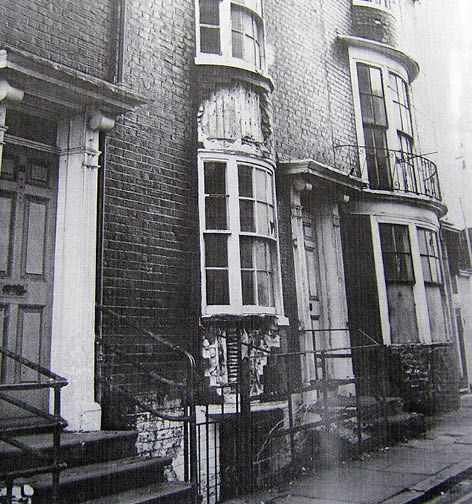
10) Photo by Brighton Borough Surveyor showing dilapidations. Image courtesy of the Royal Pavilion, Libraries and Museums, Brighton and Hove
The second, and more insidious threat came in the post-war years when Charles Street, in common with much of Brighton, entered a time of uncertainty and neglect. The nineteen-fifties saw local coach company Southdown Motor Services Ltd purchase numbers 19 - 23 with a view to demolishing and redeveloping the site.(31) The demolition thankfully never took place, but the four houses were left to deteriorate and the manager of the company a Mr Gerald Duckworth is recorded saying
“Southdown are not prepared to lay out any money in repairing the properties and are advised that the cost, in any event, is prohibitive and unrealistic."(32)
The derelict properties were attracting vandals and as the Brighton Herald of October 1968 reports,
“the company have received many complaints regarding the properties being a nuisance to adjoining owners by the dumping of refuse in the front areas, damage by vandals and infestation by vermin."(33)
Southdown’s refusal to repair and maintain the buildings led to a long and drawn out battle between the company, the council, the residents and the Regency Society – who recognised the importance of the houses and the need to retain them.
The Regency Society along with Sussex Archaeological Society, the Georgian Group, Dr Lomax the Minister of Housing as well as local government battled for four-years and by 1972 the houses had been listed and the town’s Planning Committee ordered Southdown to repair the buildings or the council would make a move to “compulsorily acquire them."(4)
South west side
Today, it can clearly be seen that No. 19 is of a different period to the rest of the terrace. An architectural plan for the property, held at ESRO, evidences the construction to have been designed and build c. 1868. It seems likely that this was not the first building to stand on that plot, however, as local directories list occupancy well before that date.
At some point in No. 19’s history the building was used as a guest house, as can be seen in the adverts reproduced below.
For most of the street’s existence, Guildford House and Marine Cottage, south of No. 19 and set at right-angles to the thoroughfare, stood where the car park is now located. The Ordnance Survey map of 1873 shows several gardens in front of Guildford House down as far as Marine Parade. To the south of Marine Cottage stood the Aldrington Hotel; built on land earlier occupied by the colonnaded Donaldsons Library (later Tuppen And Walkers’).
The library is shown in Edward Cobbys’ 1799 map of Brighton, on which is also noted the sea-bathing area reserved for ladies that stood immediately south of Charles Street. Perhaps not unsurprisingly, the Libraries promoted themselves in print as possessing fine sea views and several capital telescopes.
Guildford House and Marine Cottage seem to have been demolished sometime between 1933 and 1946, leaving an unsightly waste ground that has remained ever since. In the East Cliff Conservation Area documentation it is suggested that this section of the street suffered bomb damage during the second World War but it has not yet been possible to find documentation substantiating this.
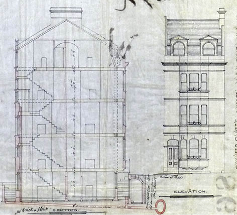
10) Detail from architectural drawing for 19 Charles Street, 1869. Image courtesy of East Sussex Record Office
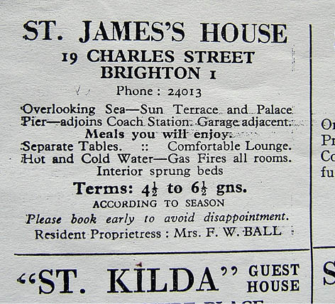
11) Advert from Brighton Directory, 1948-49. Image courtesy of the Royal Pavilion, Libraries and Museums, Brighton and Hove
Conclusion
Charles Street does not have an overtly exciting history; it is essentially an ordinary Brighton Street, but that is where its beauty lies.
This seemingly average, small street, which is used as a through road to St James’s Street, was in the late eighteenth century at the heart of Brighton’s development. As one of the first streets to be built in an area it was to become one of the most popular places to stay in the town. Without streets such as this providing the growing number of visitors to the town with quality accommodation, people may well have stopped coming, and Brighton would not be the town it is today.
Streets like Charles Street may appear unassuming, but investigate and the beginnings of Brighton’s future as a tourist centre are uncovered. Without these streets the town would lose a small but architecturally important connection to its extravagant and exciting history.
Download the Charles Street history as a .pdf (1.6Mb)
References
- Kaminski, J., (2010), ‘No lodgings to be had for love or money’ – The Business of Accommodating Visitors in Eighteenth Century Brighton in Sussex Archaeological Collections, Volume 148, p 185
- Farrant, S., (1980), Georgian Brighton 1740 – 1840, p 34. University of Sussex Centre for Continuing Education: Sussex
- ibid, p 34
- Berry, S., (2005) Georgian Brighton, p 113. Phillimore & Co Ltd: England
- Farrant, p 34
- Cobby, E., (1799) Brightenhelmstone Directory, p 7
- ibid, pp 21-22
- Farrant p 32
- ESRO
- Farrant, p 34
- Antram, N., Morrice, R., (2008), Pevsner Architectual Guides - Brighton and Hove, p 129
- Collis, R., (2010) The New Encyclopedia of Brighton, p 11. Brighton and Hove Libraries: Brighton
- Dale, A., (1976), Brighton Town and Brighton People, p 83. Phillimore & Co Ltd: England
- ibid, p 129
- ibid, p 93
- Kaminski, p 194
- Cobby, pp 21 -22
- Kaminski, p 196
- ibid, pp 21-22
- ibid, pp 21 -22
- Tucker, W., (1817), The Family Dyer and Scourer – Being a Complete Treatise on the Art of Cleaning and Dying, p 7. Sherwood, Neely and Jones: London
- Wallis., (1836) Brighton as it is, 1836, Exhibiting all the Latest Improvements in that Fashionable Watering Hole, p 44. The Booksellers: Brighton
- Unknown., (16th December 1881) A Lost Fowl, in The Argus, p 2
- ibid
- ibid
- ibid
- ibid
- ibid
- ibid
- ESRO
- Unknown., (11th October 1969) Council wants to pull down Regency homes in Brighton and Hove Herald, pp 1 - 2
- ibid
- ibid
- Unknown., (26th April 1972), It’s time to repair old houses in The Evening Argus